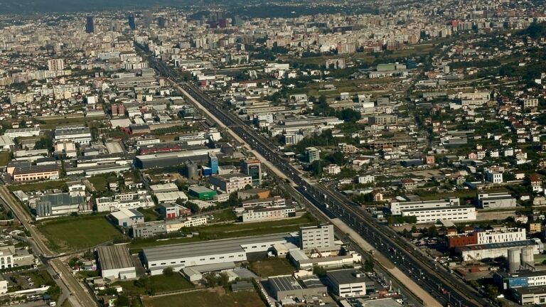
Tirana, the vibrant capital of Albania, is in the midst of a profound urban transformation. Once a city where cars ruled the roads, it is now aggressively pedalling towards a greener, more people-centric future. Central to this evolution is an ambitious, multi-faceted plan to expand its network of bike lanes, cementing cycling as a safe, efficient, and mainstream mode of transport for everyone.
This shift is not accidental; it is a core component of the city’s official urban development strategy. Recent presentations, such as the ones the BikeTirana team attended at the Tirana Cargo Bike Conference, have provided a detailed look into this vision. This article combines those insights with official governmental sources to give you the complete picture of Tirana’s cycling network.
All images and data presented in this article are credited to the Tirana Cargo Bike Conference and Active Mobility Albania. Further information and context can be found via Iden Petraj’s post on the event here.
The Strategic Vision: A Pillar of Urban Planning
Tirana’s commitment to cycling is formally enshrined in its key policy documents, most notably the Sustainable Urban Mobility Plan (SUMP). The goal is to fundamentally change how the city moves by promoting active mobility—cycling and walking—as a compelling alternative to private cars. The strategy detailed in recent presentations aligns perfectly with these official goals.
Key components of this strategy include:
- A “Minimum Grid” of Cycling Infrastructure: Forming a connected and safe core network.
- Network Completion and Extension: Expanding the grid to reach more neighbourhoods.
- Natural Bicycle Trails: Integrating green spaces and nature into the cycling experience.
- E-bike and E-scooter Sharing Schemes: Introducing new Public-Private Partnership (PPP) models, complete with charging points.
- Cargo Bike Systems: Developing sharing schemes to support sustainable logistics and family transport.
- Enhanced Parking Facilities: Building a new system for both private and shared micro-mobility vehicles.
- Education and Training: Implementing bike coaching and learning programs to build cyclists’ confidence.
- Cycle Tourism: Leveraging the new infrastructure to position Tirana as a destination for cycling enthusiasts.
This plan is supported by integrating cycling with public transport, featuring multimodal terminals, park-and-ride (P&R) facilities, and connections to major bus stations.

Mapping the Network: A Quantified Expansion
The backbone of Tirana’s cycling plan is the physical expansion of its network. The plans show a clear, phased approach, starting with a foundational “Minimum Grid” and extending city-wide.
According to the plans presented, the network is projected to grow significantly:
- Current Network: Approximately 28.5 km of existing cycling infrastructure.
- Planned Expansion: A future goal of reaching 58 km, effectively doubling the network’s current length.
This network is a mix of different lane types designed for various urban contexts:
- Existent Cycling Network: Dedicated lanes exclusively for bikes (shown in blue).
- Existent Shared Path: Wider paths shared between bikes and pedestrians.
- Completion of Minimum Grid: High-priority routes (shown in red) that will connect existing segments into a seamless core network.
- Network Completion and Extension: Future routes (shown in orange) that will extend into more residential administrative units (Njësia).
- Shared Lane for PT and Bikes: Innovative lanes designed for use by both public transport and bicycles.

Dedicated Lanes: Visualizing the Growth
Safety and convenience are paramount, which is why a key focus of the expansion is on creating dedicated, physically separated bike lanes. A detailed map illustrates the progress made and the work that lies ahead.
- Green Lines (Përfunduar / Completed): These represent the dedicated bike lanes that are already operational, forming a significant part of the inner ring and key arterial roads.
- Red Lines (Plan / Planned): These show the planned routes. Crucially, they serve to connect the fragmented green segments, creating a truly cohesive and functional network that is safe for continuous travel.

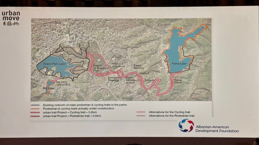
Beyond the Commute: The Recreational “Green Belt”
Tirana’s cycling vision extends into its stunning natural landscapes. The city is investing heavily in recreational trails that connect its most beloved green spaces, promoting healthy lifestyles and eco-tourism.
A flagship project is the creation of Tirana’s “Green Belt,” a major initiative supported by the Albanian-American Development Foundation (AADF). This project, part of the “urban move” program, physically connects the Grand Park of Tirana (Parku i Madh i Tiranës) with Farka Lake, creating an uninterrupted green corridor.
The project, as detailed on the AADF’s official project page, includes:
- New Cycling Trail: 5.8 km
- New Pedestrian Trail: 5.6 km
This development links existing park trails to create a vast recreational area, allowing residents and visitors to cycle or walk from the heart of the city out to the serene Farka Lake.
Governmental Backing and Official Commitment
These developments are not just proposals; they are official policy backed by the highest levels of city government. The Municipality of Tirana (Bashkia Tiranë), led by Mayor Erion Veliaj, has consistently championed active mobility.
In numerous public statements, Mayor Veliaj has reiterated his commitment, stating goals to add dozens of kilometres of new lanes. This top-level support ensures that the vision outlined in the SUMP and the General Local Plan is translated into tangible infrastructure on the ground, making Tirana a benchmark for sustainable urban development in the Balkans.
Frequently Asked Questions (FAQs)
1. How many kilometres of bike lanes does Tirana have?
According to recent plans, Tirana has approximately 28.5 km of existing cycling infrastructure. The city is actively working towards an official goal of 58 km, which involves completing a “Minimum Grid” and extending the network to more neighbourhoods as outlined in its mobility strategy.
2. Are there bike-sharing programs available in Tirana?
Yes. While earlier schemes existed, the city’s new strategy involves launching an upgraded Public-Private Partnership (PPP) for both bicycle and e-scooter sharing. The plan also includes developing innovative sharing schemes for cargo bikes.
3. Can I cycle in Tirana’s main parks?
Absolutely. The Grand Park of Tirana has existing trails, and a major project, supported by the AADF, is creating a 5.8 km cycling trail to connect it directly with Farka Lake. You can read about this “Green Belt” project on the AADF’s website.
4. What is the official future of cycling in Tirana?
According to Tirana’s official Sustainable Urban Mobility Plan (SUMP), the future is focused on a major modal shift. This includes doubling the bike lane network, fully integrating cycling with public transport, launching modern sharing schemes, and promoting Tirana as a cycle-friendly destination.
5. Is cycling in Tirana safe?
Improving safety is the primary driver behind the infrastructure projects. By creating a connected grid of dedicated, physically separated bike lanes, the Municipality of Tirana is systematically making cycling safer and more appealing for people of all ages, directly addressing the safety concerns associated with sharing roads with vehicle traffic.